Wednesday 8 April 2015
PRO-HYDRAULIC FRACKING
Our teacher of tecnology told us to post in the blog a presentation we have done about hydraulic fracking and we hope you like it.
Hidraulic frackin from margatecnojaime
Monday 16 March 2015
CAPACITORS
Adrián Álvarez Gallardo Ángel Barrios Montero
INDEX
- What is a capacitor?
- Dielectric insulator
- History
- Theory of operation
- Hydraulic analogy
CAPACITOR
WHAT IS A CAPACITOR
A capacitor (originally known as a condenser) is a passive two-terminal electrical component used to store energy electrostatically in an electric field.The forms of practical capacitors vary widely, but all contain at least two electrical conductors (plates) separated by a dielectric (insulator).

DIELECTRIC INSULATOR
A dielectric or insulator is a material that prevents the passage of current, and its function is to increase the capacitance of the capacitor.
The different materials used as dielectric permittivity has varying degrees of (different capacity for establishing an electric field).
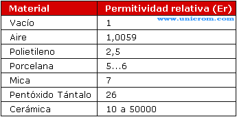
Relative permittivity of insulating materials - Electronics Area
The higher the permittivity, the greater the capacity of capacitor.
The capacitance of a capacitor is given by the formula:
Er = C x A / d
where:
- C = capacity
- Er = permittivity
- A = area between plates
- D = distance between the plates
The unit of measurement is the farad. There submultiples as miliFaradio (mF), microfarad (uF), the nanofarad (nF) and picoFarad (pF)
The main electrical characteristics of a capacitor are capacity or capacitance between plates maximum voltage (maximum voltage that is able to withstand without damage).
HISTORY
 In October 1745, Ewald Georg von Kleist of Pomerania, Germany, found that charge could be stored by connecting a high-voltage electrostatic generator by a wire to a volume of water in a hand-held glass jar. Von Kleist's hand and the water acted as conductors, and the jar as a dielectric
(although details of the mechanism were incorrectly identified at the
time). Von Kleist found that touching the wire resulted in a powerful
spark, much more painful than that obtained from an electrostatic
machine. The following year, the Dutch physicist Pieter van Musschenbroek invented a similar capacitor, which was named the Leyden jar, after the University of Leiden where he worked.
In October 1745, Ewald Georg von Kleist of Pomerania, Germany, found that charge could be stored by connecting a high-voltage electrostatic generator by a wire to a volume of water in a hand-held glass jar. Von Kleist's hand and the water acted as conductors, and the jar as a dielectric
(although details of the mechanism were incorrectly identified at the
time). Von Kleist found that touching the wire resulted in a powerful
spark, much more painful than that obtained from an electrostatic
machine. The following year, the Dutch physicist Pieter van Musschenbroek invented a similar capacitor, which was named the Leyden jar, after the University of Leiden where he worked.THEORY OF OPERATION
A capacitor consists of two conductors separated by a non-conductive region. The non-conductive region is called the dielectric. In simpler terms, the dielectric is just an electrical insulator.

HYDRAULIC ANALOGY
In the hydraulic analogy, charge carriers flowing through a wire are analogous to water flowing through a pipe. A capacitor is like a rubber membrane sealed inside a pipe. Water molecules cannot pass through the membrane, but some water can move by stretching the membrane.

Saturday 3 January 2015
GPS TOMTOM
We are students of 3rd E.S.O. and we want to explain how a program or application for GPS Navigator is designed by TOMTOM to go from point A to point B by car on the best route.

GPS TOMTOM
In 2004 the first TOMTOM browser came as hardware. Right now there are 109 navigable countries.
To make this program uses existing street, city maps, orthophotos and satellite images.The maps are redrawn schematically in digital format. This is the first layer. Another layer becomes more above: the names of streets, signs (including information on maximum speed, senses movement of the streets, speed radars, direction boards, etc), the numbers of the streets and points of interest, relief and finally monuments and unique elements.
And to make this work you have to move to the place you are mapping with "Mobile Mapping"

This is a van carrying a diferential GPS, camera 360º, a laser scanner, a 3D gyroscope, an odometer and a computer to record all data should complement the map is used.
The laser scanner generates a three-dimensional image points of the enviroment by passing the van.
Also is the information transmitted GPS navigators position themselves.
When maps are released to users all participate with their data.Then you can know where it has gone that browser, which took effect or how fast passed. All these data are displayed with a web tool called " Cartopía".

This tool checks the layout of the streets and roads according to the map. If there are errors, we proceed to correct them. It also checks wether the directions of movement are correct, if there are roundabouts, even if there are new streets that are not on the map and thanks to a GPS pased by and left the trail.
To make this program uses existing street, city maps, orthophotos and satellite images.The maps are redrawn schematically in digital format. This is the first layer. Another layer becomes more above: the names of streets, signs (including information on maximum speed, senses movement of the streets, speed radars, direction boards, etc), the numbers of the streets and points of interest, relief and finally monuments and unique elements.
And to make this work you have to move to the place you are mapping with "Mobile Mapping"
This is a van carrying a diferential GPS, camera 360º, a laser scanner, a 3D gyroscope, an odometer and a computer to record all data should complement the map is used.
The laser scanner generates a three-dimensional image points of the enviroment by passing the van.
Also is the information transmitted GPS navigators position themselves.
When maps are released to users all participate with their data.Then you can know where it has gone that browser, which took effect or how fast passed. All these data are displayed with a web tool called " Cartopía".
This tool checks the layout of the streets and roads according to the map. If there are errors, we proceed to correct them. It also checks wether the directions of movement are correct, if there are roundabouts, even if there are new streets that are not on the map and thanks to a GPS pased by and left the trail.
Subscribe to:
Posts (Atom)